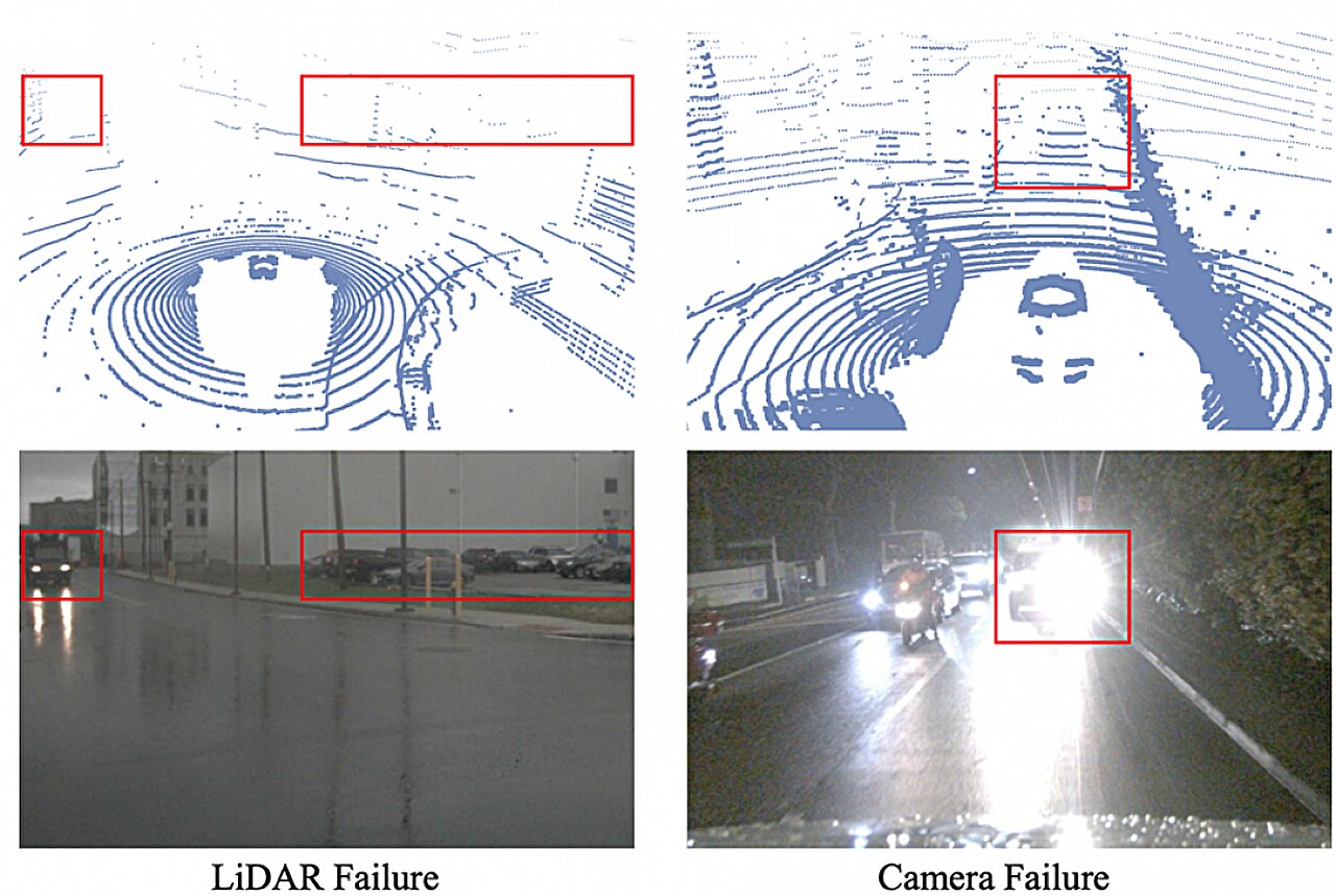
For all the aggressive commercial timelines published by robotaxi operators and Level 3 automated driving consortia, the modern autonomous vehicle (AV) remains an engineered creature of fair weather. A sudden tropical squall across Singapore, torrential summer downpours in Shenzhen, or thick radiative winter fog over the autobahn corridors of Germany regularly expose the brittle limits of autonomous perception stacks. While production camera arrays lose optical contrast and battle droplet occlusion on exterior lens covers, standard near-infrared pulsed time-of-flight sensors suffer catastrophic backscatter, filling spatial voxel maps with phantom obstacles.
The latest research development emerging from the Singapore University of Technology and Design (SUTD) directly confronts this operational design domain (ODD) constraint. By introducing an adaptive dual-sensor fusion model that mathematically balances optical camera telemetry against three-dimensional LiDAR point clouds, the researchers claim substantial improvements in detecting pedestrian silhouettes and spatial bounding boxes under simulated and real adverse weather conditions. However, evaluating this technical milestone requires looking beyond academic accuracy metrics to interrogate the underlying physics of photon scattering, edge inference latency, and automotive-grade commercial feasibility.
The Atmospheric Scattering Barrier: Why Photons Fail in Precipitation
To understand why adverse weather sensor fusion remains the most contested frontier in autonomous systems engineering, one must return to optical physics. Automotive LiDAR systems overwhelmingly rely on near-infrared (NIR) wavelengths, predominantly 905 nanometers (nm) powered by inexpensive pulsed edge-emitting laser diodes or VCSEL arrays, alongside costlier 1550nm indium gallium arsenide (InGaAs) fiber lasers. Under ideal conditions, these wavelengths yield sub-centimeter ranging accuracy across a 200-meter field of view.
When rain, fog, or airborne particulate matter enters the optical channel, the transmission medium changes abruptly from clear atmospheric air to a dense suspension of dielectric water droplets. In fog, where droplet radii range between 1 and 20 micrometers, optical propagation transitions into the realm of Mie scattering, where the particle radius is comparable to the wavelength of light. The result is intense backscattering: the emitted photons bounce off moisture particles immediately in front of the transceiver aperture rather than reaching target objects downrange. In heavy rain, where droplet sizes exceed millimeters, geometric optics and Rayleigh scattering mechanisms degrade the laser energy through direct attenuation and multi-path reflection.
For automotive cameras, the degradation follows a parallel, equally destructive trajectory. Droplets adhering to protective glass alter refractive indices, distorting spatial geometry. Airborne suspended water creates intense light diffusion, effectively flattening color saturation, eroding edge boundaries, and compressing dynamic contrast ranges. Under heavy precipitation, an unassisted neural network processing 8-megapixel automotive camera feeds frequently misclassifies pedestrian contours as visual noise or fails entirely to compute depth cues from disparity maps.
Dissecting the SUTD Algorithmic Architecture: Adaptive Fusion Under Stress
The academic team at SUTD structured their breakthrough around the fundamental asymmetry of sensor degradation. Rain and fog do not impact optical cameras and LiDAR systems in an identical manner or at the exact same spatial coordinates. A dense mist may obliterate a 905nm LiDAR point cloud by returning dense clusters of zero-distance noise, yet a high-dynamic-range (HDR) camera can still register the chrominance and lateral position of a pedestrian equipped with reflective clothing. Conversely, at night under blinding precipitation, a camera's signal-to-noise ratio collapses entirely, whereas a focused LiDAR beam can still penetrate gaps between falling water droplets to return sparse 3D spatial points.
Traditional fusion architectures in automated driving typically divide into early-fusion (raw data concatenation) and late-fusion (combining independent bounding-box outputs from separate perception pipelines). Both approaches fail under adverse weather conditions. Early fusion contaminates the neural network pipeline with corrupted raw inputs, generating systemic hallucinations. Late fusion fails because if both individual detectors fall below confidence thresholds due to environmental degradation, the downstream fusion node receives zero valid bounding boxes to reconcile.
The SUTD framework employs a dynamic, intermediate feature-level fusion paradigm. By extracting intermediate convolutional feature maps from the optical feed while simultaneously projecting raw LiDAR point clouds into a range-view or bird's-eye-view (BEV) tensor, the model implements an environmental uncertainty weighting mechanism. When the model detects spatial noise profiles characteristic of rain backscatter within the LiDAR channel, it dynamically downweights the spatial confidence of those corrupted point voxels while borrowing semantic structural priors from the optical channel. Conversely, when optical contrast deteriorates below usable levels, the system elevates the geometric depth data extracted from surviving unscattered LiDAR returns.
| Perception Architecture | Adverse Weather Mechanism | Compute Overhead | Sensor BOM Cost Impact | Mass-Production Readiness |
|---|---|---|---|---|
| SUTD Dynamic Intermediate Fusion | Adaptive spatial-semantic confidence weighting across modalities | High (Requires cross-modal attention transformers) | Neutral (Optimizes existing 905nm LiDAR + Camera suite) | Low (Academic validation; uncertified for ASIL-D) |
| Tesla Vision-Only (Occupancy Network) | Pure temporal neural reconstruction via camera feeds | Moderate (Runs on custom FSD HW3/HW4 silicon) | Lowest (Zero active emission sensors; cameras only) | High (Mass deployment, but severe rain/fog limitations) |
| Waymo / Cruise Multi-Modal Array | Hardware redundancy: 1550nm/905nm LiDAR, 4D Radar, Cameras | Extensive (Multi-kilowatt server racks in trunk) | Extremely High (Estimated >$35,000 sensor package) | Medium (Constrained to bounded geofenced commercial fleets) |
| Tier-1 Standard L2+ Fusion (Mobileye/Bosch) | Classical late-fusion with heuristic safety gates | Low (Runs on 15W–30W automotive-grade SoCs) | Moderate (Single front camera + 77GHz radar + optional LiDAR) | Highest (Millions of production passenger vehicles) |
The Compute Bottleneck and Automotive Sourcing Constraints
While algorithmic breakthroughs in academic laboratories illustrate what is mathematically possible using unconstrained workstations, the reality of the automotive tier-1 supply chain operates under brutal thermal, electrical, and commercial parameters. Deploying a complex cross-modal neural network into a road-going electric vehicle requires fitting within an electronic control unit (ECU) power envelope that typically cannot exceed 40 to 65 watts for the entire perception domain controller.
High-end robotaxi prototypes operated by Waymo or Baidu Apollo bypass this constraint by converting vehicle cargo areas into liquid-cooled server rooms consuming up to 2.5 kilowatts of auxiliary power. In an electric vehicle, an auxiliary draw of that magnitude reduces driving range by 10 to 15 percent before the vehicle has even accelerated. For volume automotive manufacturers like Volkswagen, General Motors, or Geely, deploying multi-thousand-dollar liquid-cooled computer systems to process adverse-weather fusion algorithms is commercially impossible.
Automotive system-on-chip (SoC) platforms, such as the Nvidia DRIVE Orin-X (delivering 254 TOPS at roughly 45–50W), Qualcomm Snapdragon Ride, or Horizon Robotics Journey 5, operate on rigid memory bandwidth constraints. Intermediate feature-level fusion algorithms that demand cross-attention mechanisms between high-resolution camera feeds (e.g., eight 8MP cameras streaming at 30 fps) and dense LiDAR point clouds (over 1.5 million points per second) quickly exhaust shared LPDDR5 memory channels. If the latency of an adverse-weather fusion algorithm stretches beyond 35 milliseconds, the perception pipeline introduces dangerous braking lag. At highway speeds of 120 km/h, every 30 milliseconds of inference latency translates to a full meter of unmonitored vehicle travel.
Global Strategic Divergence: Software Workarounds vs. Hardware Redundancy
The quest to solve adverse-weather perception reveals a fundamental strategic divergence between Western legacy automakers, Chinese EV innovators, and autonomy pure-plays. Each camp approaches the sensor degradation problem through a fundamentally different economic philosophy.
Tesla remains the extreme outlier, having stripped ultrasonic sensors and radar units from its production fleet in favor of a vision-only paradigm relying on occupancy networks and temporal queues. Tesla argues that biological humans navigate rain and fog using two optical sensors (eyes) backed by biological intelligence. However, automotive optical sensors lack the dynamic focal adaptation, rapid micro-saccadic adjustments, and contextual common sense of human drivers. In severe fog, camera-only approaches routinely hit an absolute physical boundary: if photons cannot penetrate the optical medium, no deep neural network can reconstruct missing ground-truth geometry without fabricating hallucinations.
At the opposite end of the spectrum, Chinese automakers operating in the hyper-competitive domestic market—such as NIO, XPeng, and Li Auto—have adopted an aggressive hardware-stuffing approach. Roof-mounted pods housing 126-line or 192-line 905nm LiDARs from suppliers like Hesai Technology and RoboSense have become standard consumer signifiers of technological luxury. Yet, Chinese OEMs are discovering that merely mounting a LiDAR on a vehicle roof does not solve wet-weather operational failures. When high-speed driving splashes road salt, mud, or road film across the sensor cover glass, the hardware becomes blind unless paired with complex fluid-cleaning jets and aerodynamic air knives, or rescued by robust algorithmic fusion architectures such as the one developed by SUTD.
Meanwhile, traditional global Tier-1 suppliers, including Continental, Bosch, and ZF, are turning their attention toward 4D imaging radar operating in the 76–81 GHz spectrum. Millimeter-wave radar pulses possess wavelengths thousands of times longer than near-infrared laser light, allowing them to pass through rain droplets, heavy snow, and dense particulate clouds with negligible attenuation. By scaling horizontal and vertical angular resolution through high-channel MIMO antenna arrays, 4D radar offers point-cloud-like spatial returns entirely impervious to the weather degradation that plagues both cameras and LiDAR.
The Reality Check: Interrogating Lab Demos Against Production Physics
The academic publication of the SUTD dual-sensor fusion model is an admirable theoretical contribution, but industry observers must treat claims of solving adverse-weather autonomous driving with disciplined skepticism. The gap separating a published paper from an ASIL-D functional safety-certified production deployment is notoriously wide.
First, academic datasets frequently rely on simulated weather degradation. Rendering artificial fog via depth-map attenuation or overlaying synthetic rain streaks across camera imagery fundamentally fails to capture the chaotic micro-physics of actual operational environments. Real rainfall does not deposit clean, uniform streaks across a camera sensor; it creates turbulent mist patterns, irregular droplet lensing, and reflective backscatter off pavement puddles that generate complex optical distortions. Similarly, real-world fog is rarely homogeneous; varying densities and ambient lighting conditions create localized saturation zones that confuse academic confidence-weighting models.
Second, the SUTD research primarily demonstrates success in pedestrian and obstacle bounding-box tracking. In safety-critical Level 3 automated driving, maintaining a 3D bounding box is only half the battle. The system must also determine semantic surface driveability, detect lane markers obscured by pooling surface water, and differentiate between a harmless puddle reflecting oncoming headlights and a deep pothole concealed beneath standing water. An algorithm that successfully tracks an upright pedestrian in mist may completely fail when tasked with detecting road boundaries on an unlit rural highway during a torrential downpour.
Finally, there is the unyielding law of physical limits. Algorithms cannot invent data that has been physically eliminated by environmental scattering. If a 905nm LiDAR beam experiences complete spatial extinction due to dense radiative fog over a 100-meter distance, no amount of statistical weighting can retrieve the lost photons. At that point, the model is merely guessing based on historical temporal frames or low-confidence optical feeds. In mission-critical automotive safety, statistical guessing is unacceptable.
Regulatory Mandates, Liability Shifts, and Homologation Hurdles
The challenge of adverse-weather driving is transitioning from an engineering puzzle into an existential legal barrier for automotive OEMs. The global deployment of Level 3 systems—where legal liability for collisions officially transfers from the human occupant to the vehicle manufacturer—is heavily gated by operational design domain parameters.
Under United Nations Regulation 157 (UN R157), which governs Automated Lane Keeping Systems (ALKS), Level 3 systems are legally mandated to monitor their own operating limits continuously. If adverse weather causes sensor degradation that prevents the system from meeting safe braking and collision-avoidance criteria, the automated system must initiate an immediate, controlled Transition Demand (TD) to the human driver. If the driver fails to respond within a mandatory handover window (typically 10 seconds), the vehicle must execute a Minimum Risk Maneuver (MRM), safely pulling onto the shoulder or coming to a controlled stop within its lane.
Currently, certified Level 3 systems on the market, such as Mercedes-Benz's Drive Pilot, restrict operational availability to clear weather, daytime or illuminated conditions, and moderate highway speeds (up to 95 km/h in Germany). The moment onboard sensors detect rain via windshield optical sensors or ambient road spray, Drive Pilot disengages and refuses activation. Automakers cannot afford to take risks: accepting legal liability during a rainstorm when sensor fusion reliability is governed by non-deterministic neural networks exposes manufacturers to catastrophic tort liability and massive regulatory recalls.
Furthermore, cross-border deployment of autonomous perception software faces deepening regulatory scrutiny. Software architectures heavily dependent on continuous over-the-air (OTA) updates and cloud-based HD map calibration run into strict data sovereignty barriers. China’s Data Security Law and Personal Information Protection Law strictly limit the collection and transmission of high-resolution spatial mapping data, requiring localized algorithm training. Any multi-sensor fusion stack developed in international research hubs must navigate these data compliance silos before achieving global commercial homologation.
Strategic Outlook and Executive Scenarios
As the automotive industry navigates the complex transition toward automated driving systems, the technical and commercial trajectory of adverse-weather perception will dictate supply chain winners and losers over the next decade.
Bull Case
Intermediate feature-level fusion models like SUTD's architecture are successfully distilled into highly compressed, quantized neural networks capable of executing on mainstream 30W automotive SoCs. Tier-1 suppliers package these algorithms directly into standardized perception middleware, significantly widening the operational envelope of consumer Level 3 systems without requiring costly 1550nm LiDAR or complex mechanical cleaning systems. Consumer adoption surges as automated highway pilots remain engaged during rain and light fog, unlocking massive software subscription revenues for OEMs.
Base Case
Algorithmic dual-sensor fusion achieves modest, incremental improvements in Level 2+ advanced driver-assistance systems, but fails to deliver the six-sigma reliability required for unsupervised Level 3 operation in severe weather. Automakers continue to impose strict operational design domain cutoffs, instructing vehicles to hand back control to the human driver at the first sign of heavy precipitation. Mainstream vehicle manufacturers avoid expensive exotic sensors, opting instead to wait for next-generation 4D imaging radar to reach automotive cost parity as the primary adverse-weather backup.
Bear Case
High-profile accidents involving autonomous test vehicles operating in low-visibility environments trigger severe regulatory crackdowns in North America, Europe, and Asia. Regulators refuse to certify deep-learning-based sensor fusion models that cannot provide deterministic, explainable safety verifications under adverse weather. The autonomous driving industry is forced into a costly hardware-centric retrenchment, mandating high-frequency cleaning mechanisms, expensive multi-wavelength laser emitters, and military-grade radar suites that render consumer-facing Level 3 automated driving economically unviable for all but ultra-luxury vehicles.
Strategic Directives for Automotive Executives
- Prioritize Edge Inference Efficiency Over Benchmark Metrics: Do not evaluate academic perception algorithms based solely on open-source benchmark accuracy. Interrogate the memory bandwidth, tensor core utilization, and latency penalty of cross-modal attention networks running on real-world ASIL-D production silicon.
- Hedge Optical Investments with 4D Imaging Radar: Recognize that optical and near-infrared sensors share common physical vulnerabilities in dense fog and rain. Allocate engineering resources toward 4D radar integration to provide orthogonal, weather-resilient physical telemetry that software algorithms cannot synthetically recreate.
- Design for Graceful Degradation and Deterministic Fallbacks: Ensure that adverse-weather fusion models incorporate hard-coded, deterministic safety bounds rather than relying purely on probabilistic confidence weighting. In safety-critical scenarios, knowing precisely when a sensor is blind is far more valuable than attempting to guess through the noise.
- Account for Mechanical and Environmental Cleanliness: Algorithms cannot process data that never hits the sensor aperture. Pair software-level fusion investments with physical sensor maintenance solutions, including hydrophobic coatings, thermal heating elements to prevent ice accumulation, and high-pressure fluid cleaning nozzles.